You
are receiving this because your address is subscribed at: www.jaunay.com/newsletter.html |
|
 |
| No: 79 |
September 2012
|
|
News September seminars 8: Climbing the genealogy barriers, Flinders University of SA 9:15am to 4:45pm October seminars 10: Introduction to FH research (over 7 weeks with sessions of 1.5 hrs each), WEA Centre Adelaide 8:00 to 9:30pm 13: Where did I come from? Fleurieu Peninsula Family History Group, 1:00 to 4:00pm (free but bookings essential) 17: Using South Australian resources in family history, Payneham Library 10:00am to 1:00pm 26: Tracing your English ancestor, WEA Centre Adelaide 6:30 to 9:30pm November seminars 11: Coming to grips with the new FamilySearch, WEA Centre Adelaide 10:00am to 1:000pm See the seminar program for more details and bookings. Adelaide Proformat closed We will be taking a break and closed 8 September to 1 October. Queensland birth certificates Following a review of the embargoed period for general public access to birth, marriage and death certificates in Queensland, that state has extended the embargoed period for births from 1 August 2012 to 100 years. It was previously 80 years. Irish Lives Remembered Readers with Irish interests may like to subscribe to a new free online newsletter. Go to: irishlivesremembered.ie South Australia's first landowners 1835–41 In this article we acknowledge that the earlier occupiers of the land in South Australia were the indigenous people of South Australia. This article relates to the European concept of owning the land through purchase from the previous owner and in this case that was the colonial government who assumed the land was previously unoccupied! |
In
this issue: |
|
Graham Jaunay Services
|
| When determining the structure of the new colony it was deemed that land should be sold in small sections (ideally about 80 acres) at a cost sufficient to fund the migration of labourers. The South Australia Colonisation Act 1834 appointed commissioners, called The Colonisation Commissioners for South Australia, to oversee the sale and leasing of land in South Australia to British subjects. The Act required that the colony was to be self-sufficient and a £20,000 surety had to be created and £35,000 worth of land had to be sold in the new colony before any settlement was permitted. These conditions were fulfilled by the end of 1835. The Act specified the minimum price of land at twelve shillings per acre regardless of the quality. The money raised by the sale and leasing of land constituted what was called an Emigration Fund which was to cover to the cost conveying immigrant labourers and their families from Great Britain and Ireland. The survey and staking out of sections by William Light’s survey teams for the Adelaide town acres began on 11 January 1837 and was completed on 10 March; the first allocation of purchased land being on 28 March by ballot. Surveys of country lands on the Adelaide plains commenced in April 1837. By November about 59,000 acres had been completed. The first 437 purchasers in England of Preliminary Land Orders were entitled to priority selection by ballot conducted on 28 March 1838 of a town acre and a 134 acre country section—cost: £81-0-0 (effectively 12 shillings an acre). These were surveyed in the prime locations adjoining the diagonal routes and on the best soils east to the foothills. For a good example, Thomas Whistler purchased three town acres and these enabled him to select three country sections. The remainder of the Adelaide plains were laid out, for the most part, in 80 acre sections as originally proposed. All land was to be surveyed before sale and rural land was to be initially sold in 80 acre parcels at a minimum price of £1 per acre and in contiguous blocks for any individual. The first surveys were confined to Preliminary Districts, thes 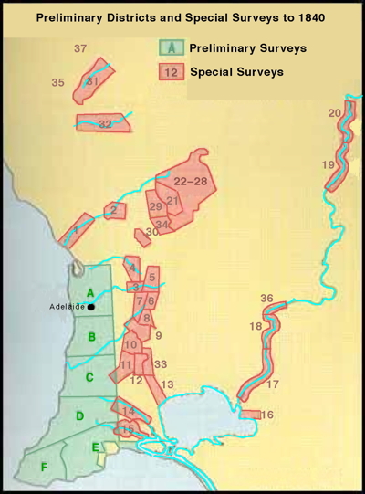 e extended from the Adelaide Plains to Cape Jervis on the Fleurieu Peninsula (marked in green on the map) plus 2 districts on Kangaroo island. Within these districts, purchasers could select wherever they wished, priority of choice being determined by lot. These were not ready until 100,000 acres had been surveyed which was achieved and announced on 18 May 1838. e extended from the Adelaide Plains to Cape Jervis on the Fleurieu Peninsula (marked in green on the map) plus 2 districts on Kangaroo island. Within these districts, purchasers could select wherever they wished, priority of choice being determined by lot. These were not ready until 100,000 acres had been surveyed which was achieved and announced on 18 May 1838.The South Australian Company gained provision for Special Surveys, previously regulated for but not enacted due to the delays in surveying the Preliminary Districts. These were conducted and from January 1839 gave advantage to those with substantial capital to become large-scale landowners who often picked out the best parcels of land. Intending purchasers who paid £4000 could ask for a Special Survey of 15,000 acres subdivided into 80 acre sections (16,000 from October 1839) and with the right to select any 4000 acres in a compact block, but in such a manner that the extent of water frontage did not exceed two miles. A number of Special Surveys were conducted and the following 37 had been completed by the end of 1840. 1: North Para (Gawler) River—GM Stephen (the 9th survey) 2: Junct of Gawler & Para Rivers (Gawler)—H Murray, J Reid & others (8th survey) 3: Torrens River—SA Coy (28th survey 20 Jul 1839) 4: Sources of the Para River—JB Hack (3rd survey: 16 Jan 1839) 5: The streams and tributaries of the Torrens—SA Coy (14th survey) 6 & 7: Sources of the Onkaparinga River—SA Coy (4th survey)—Originally called Sources of the Angas River. 8: North of Mount Barker—M Smillie (6th survey: 24 Jan 1839) 9: Mount Barker District—WH Dutton (1st survey: 11 Jan 1839) 10: The Three Brothers west of Mount Sturt—JB Hack (11th: 31 Jan 1839) 11: The Meadows south and south-west of Mount Sturt—C Flaxman (7th survey) 12: South-east of the Three Brothers and east of The Meadows—J Morphett 13: Lower course of the River Angas—G Hall and W Mein (19th survey) 14: Mouth of the Finniss—R Cook and others (29th survey) 15: Currency Creek—Currency Creek Association (33rd survey) 16: East end of Lake Alexandrina—Neil Malcolm (30th survey) 17: Lower course of the Murray (Wellington)—J Morphett (17th survey) 18: Lower course of the Murray—J Morphett (error on map see note) (18th survey) 19: Below the elbow of the Murray (Moorundie)—EJ Eyre & O Gilles (26th survey) 20: Below the elbow of the Murray—G Hall (24th survey) 21: To the north-east of Lyndoch Valley—Gilbert and Rowland (27th survey) 22: Light Pass, Flaxman Valley and Barossa Range—GF Angas (12th survey) 23: Light Pass, Flaxman Valley and Barossa Range—GF Angas (13th survey) 24: Light Pass, Flaxman Valley and Barossa Range—GF Angas (15th survey) 25: Light Pass, Flaxman Valley and Barossa Range—GF Angas (20th survey) 26: Light Pass, Flaxman Valley and Barossa Range—GF Angas (21st survey) 27: Light Pass, Flaxman Valley and Barossa Range—GF Angas (22nd survey) 28: Light Pass, Flaxman Valley and Barossa Range—GF Angas (23rd survey) 29: Lyndoch Valley—SA Coy (2nd survey: 14 Jan 1839) 30: On a branch of the River Para—GA Anstey 31: On the River Wakefield—Lambert, ER Rix and RA Slaney (35th survey) 32: On the River Light—Secondary Town Assoc & Eyre & Bonney’s Stations (36th survey) 33: About the upper course and branches of the River Angas—GF Davenport (37th) 34: Barossa Special Survey—G Stevenson & 7 others ((32nd survey 24 Nov 1839) – this survey was not included on the original map 36: Thirty nine Sections Special Survey (Mannum)—William Leigh & others (Feb 1840) – this survey was not marked on the original map Surveys not outlined on map— 35: Hutt River Special Survey (west of #31)—P Horrocks & J Morphett (34th survey: 2 Dec 1839) this survey was not included on the original map 37: Upper Wakefield Special Survey (north of #31)—A Young (29 Oct 1840) – this survey was not included on the original map The original map was drawn by John Arrowsmith and can be viewed online (see a small section below) and purchased if required from the National Library of Australia Digital Map collection (Map RM2629). See following image. Note: There were also surveys covering areas outside this map at: Boston Bay (10th & 11th surveys)—Feb 1839 Rivoli Bay (29,00 acres—Jan 1839) Port Victoria (JB Hack & J Russell—10 May 1839) Port Vincent (JB Hack & J Russell—Jun 1839 16th survey) Although the system of pastoral leases did not commence until the early 1840s there were squatters occupying land outside the Preliminary Districts in this period. Most notable were Hack and Finniss’ cattle stations on the land absorbed into Dutton’s Special Survey of the Mount Barker district. But there were others including stations operated by Fenn, Scott, Jones, Bourchier, Milne, and the Joint Stock Cattle Company's dairy on the Angas River. John Bristowe Hughes was squatting north of the settled area at Bundaleer by mid 1840. 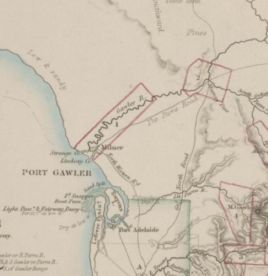 Persons purchasing land in South Australia from 1835 to 1841 are now available together with details of their purchase on a CD that can be purchased from Gould Genealogy. |
|
| To
unsubscribe send a blank email via the following link using the same
address you subscribed to: newsletter-leave@jaunay.com |