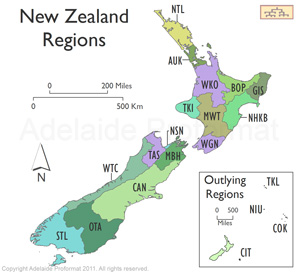
New Zealand
Prior to 16 Nov 1840 New Zealand was part of New South Wales as outlined under Australia.
There are 16 regions of New Zealand. 11 are governed by an elected regional council, while 5 are governed by territorial authorities (the second tier of local government) which also perform the functions of a regional council and thus are known as unitary authorities. The Chatham Islands Council is similar to a unitary authority, but is authorised under its own enabling legislation.
The 10 Chatham Islands, part of the country since 1842, are located 800 km east of Christchurch. The other outlying island groups to the south include Bounty, Andpodes, Campbell and Auckland and all are uninhabited.
The islands to the north including Cook, Niue, Tokelau and Kermadec are inhabited although the latter comprising of 6 main islands is only staffed by meteorologists and conservation officers on the island of Raoul.
Cook Islands
The Kingdom of Rarotonga was established in 1858 and in 1888 it became a British protectorate by the request of Queen Makea Takau, mainly to thwart the French. In 1893 the name was changed to the Cook Islands Federation in recognition of Captain Cook.
In 1901 administrative control was transferred to New Zealand. In 1965 the Cook Islands became a self-governing parliamentary democracy of 15 small islands whose citizens are citizens of New Zealand with the status of Cook Islands nationals. New Zealand oversees the country's foreign relations and defence.
On 11 June 1980, the United States agreed on the maritime border between the Cook Islands and American Samoa and also relinquished claims to the islands of Penrhyn, Pukapuka, Manihiki, and Rakahanga.
In 1990 the maritime boundary between the Cook Islands and French Polynesia was ratified.
For more information go to the specific page on the Cook Islands.
Niue
See the specific page on Niue.
Tokelau
The three atolls of Tokelau, a mere 10 km2, operated independently of each other and were governed by chiefs. In 1877 the islands were included under the protection of Great Britain by an Order-in-Council which claimed jurisdiction over all unclaimed Pacific Islands.
The British government annexed Tokelau, then called the Union Islands, to the colony of the Gilbert and Ellice Islands and transferred Tokelau to New Zealand administration in 1926, abolishing the islands' chiefdoms. In 1946 the name was changed from The Union Islands to the Tokelau Islands and in 1976 to Tokelau.
By the Tokelau Act of 1948, sovereignty over Tokelau was transferred to New Zealand. The Tokelau Amendment Act of 1996 conferred legislative power on the local legislature known as General Fono.
Tokelau has rejected two recent attempts by New Zealand to impose a self-governing state in the same style as exists with the Cook Islands.
 |
|
Region
|
Main town
|
Location
|
Code
|
|
1
|
Northland
|
Whangarei
|
North Island
|
NZ-NTL
|
|
2
|
Auckland
|
Auckland
|
North Island
|
NZ-AUK
|
|
3
|
Waikato
|
Hamilton
|
North Island
|
NZ-WKO
|
|
4
|
Bay of Plenty
|
Whakatane
|
North Island
|
NZ-BOP
|
|
5
|
Gisborne
|
Gisborne
|
North Island
|
NZ-GIS
|
|
6
|
Hawke's Bay
|
Napier
|
North Island
|
NZ-HKB
|
|
7
|
Taranaki
|
Stratford
|
North Island
|
NZ-TKI
|
|
8
|
Manawatu-Wanganui
|
Palmerston North
|
North Island
|
NZ-MWT
|
|
9
|
Wellington
|
Wellington
|
North Island
|
NZ-WGN
|
|
10
|
Tasman
|
Richmond
|
South Island
|
NZ-TAS
|
|
11
|
Nelson
|
Nelson
|
South Island
|
NZ-NSN
|
|
12
|
Marlborough
|
Blenheim
|
South Island
|
NZ-MBH
|
|
13
|
West Coast
|
Greymouth
|
South Island
|
NZ-WTC
|
|
14
|
Canterbury
|
Christchurch
|
South Island
|
NZ-CAN
|
|
15
|
Otago
|
Dunedin
|
South Island
|
NZ-OTA
|
|
16
|
Southland
|
Invercargill
|
South Island
|
NZ-STL
|
|
17
|
Chatham Islands
|
Waitangi
|
|
NZ-CIT
|
|
|
Cook Islands
|
Avarua
|
|
COK
|
|
|
Niue
|
Alofi
|
|
NIU
|
|
|
Tokelau
|
Nukunonu
|
|
TKL
|
|