Ireland including Northern Ireland
When seeking information about ancestors, knowledge of where they lived is paramount to locating records. When researching regions before the start of civil registration this becomes even more significant as the important records were generated at the local level. Knowing where the family lived will point you towards the appropriate repositories.
The political geography of Ireland can be traced with some accuracy from the 6th century when Ireland was divided into petty kingdoms. The Norman invasion of Ireland commenced in 1169 and was followed in 1172 by the invasion of Henry II. The English governed Ireland by dividing the country into counties in the late 12th and early 13th centuries. The counties were usually made up from an amalgamation of various smaller Irish territories which suited the colonial administration at the time and had little basis in the older tribal boundaries.
The idea of counties was first introduced to Ireland following the Anglo-Norman invasion in the twelfth century. At that time 12 counties were defined in Leinster and Munster. By 1200 there were also counties of Connacht, Cork, Kerry, Kilkenny, Limerick, Louth and Tipperary, Waterford and Wexford. The process continued over time and the County of Roscommon was separated from Connacht before 1292. The first session of the Irish parliament in 1297 created the new counties of County Kildare, Meath and Ulster. Carlow, then larger than today dates from around 1306. From that time until the mid-sixteenth century county borders were not well defined reflecting the weakness of English control during that period. During the reign of Elizabeth 1 the counties of Longford, Clare, Galway, Sligo, Mayo, Roscommon, Leitrim, Armagh, Monaghan (1585), Tyrone, Derry, Donegal, Fermanagh (1585), and Cavan were formed. But still the county borders were not very clearly set out. However, improvements in mapping gradually resulted in the counties as we know them today. Wicklow, surveyed and distinguished into a county in 1606, was the last county to be formed although it was created on paper in 1542.
Co Coleraine was established 1585.
Co Louth previously known as Co Oriel(or Uriel).
Co Londonderry (now Derry) was created from Co Coleraine 1613.
Cork and Kerry gained Co Desmond, Co Nether and Co Upper Tyronne in 1606.
Co Carlow was known as Caterlaugh prior to losing its north to Co Wicklow in early 1600s.
Co Antrim created from Co Twescard in 1584.
Co Ladcathel (or Lecale), Co Newtownards (or Blathewyc) and Co Ards (or Del Art) absorbed into Co Down then known as Downshire.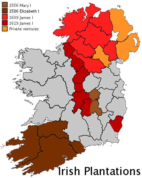
The Tudor administrations finalised the division of Ireland into counties. Westmeath was separated from Meath (often called East Meath) in 1543. Henry VIII introduced a new policy to pacify the midland areas through establishing a plantation by confiscating lands and granting them to non-Irish nobles. Mary I and Elizabeth I undertook similar actions and the concept was continued by James I, Charles I and Cromwell. (See adjacent map - note the shaded areas represent where plantations were established and are not meant to imply the whole shaded area was a single plantation.) In 1556 King’s County and Queen’s County were created and the Kingdom of Connacht was broken up into the counties of Galway, Mayo and Sligo, while Leitrim was separated from Roscommon in 1565. At the same time County Clare was created and moved from Munster to Connacht, being returned to Munster in 1602.
In 1583 County Longford was formed from part of Westmeath and transferred to the Province of Connacht. The Province of Ulster was the last to be split into counties with the counties of Antrim and Down established early in the 16th century. These were joined in 1584/5 by the Counties of Armagh, Coleraine (later reformed as Londonderry), Donegal, Fermanagh, Monaghan and Tyrone. County Cavan was also formed in 1584 and transferred from Connacht to Ulster Province.
The last county to be formed was County Wicklow in 1606–1607, taking in the southern part of Dublin (with the exception of three enclaves of (mainly) church property), and the northern part of Carlow. Former counties include: County Coleraine, which formed the basis of County Londonderry, the counties of Nether and Upper Tyrone and Desmond which was, in 1606, split between counties Cork and Kerry. Other names seen on old maps include old names for County Carlow in the period before much of the north of that county was taken into Wicklow in the early 17th century.
The boundaries of the traditional counties have changed on a number of occasions. In 1898 changes were made to the boundaries of Counties Galway, Clare, Mayo, Sligo, Waterford, Kilkenny and Louth.
A number of counties have enjoyed other names—Armagh was Ardmagh; Donegal was Tyrconnell / Tirconnell / Tirconaill, Galway was Gallive; Laois was Queens County; Offaly was Kings County; Wexford was Loughgarman; Wicklow was Kilmantan.
 |
Provinces |
|
| Connaught; Leinster; Munster; Ulster |
| |
|
| Counties |
|
| Antrim ANT |
Armagh ARM |
| Carlow CAR |
Clare CLA |
| Cork COR |
Donegal DON |
| Down DOW |
Dublin DUB |
| Fermanagh FER |
Galway GAL |
| Kerry KER |
Kildare KID |
| Kilkenny KIK |
Londonderry LDY |
| Leitrim LET |
Leix LEX |
| Limerick LIM |
Longford LOG |
| Louth LOU |
Mayo MAY |
| Meath MEA |
Monagham MOG |
| Offaly OFF |
Roscommon ROS |
| Sligo SLI |
Tipperary TIP |
| Tyrone TYR |
Waterford WAT |
| Westmeath WEM |
Wexford WEX |
| Wicklow WIC |
|
|
|
|
|
|
|
| |
|
|
The place codes used for Ireland are known as Chapman Codes after their innovator, Colin Chapman. These are used by family historians to identify the counties of Ireland.
When seeking information about ancestors, a knowledge of where they lived is paramount to locating records. When researching regions before the start of civil registration this becomes even more significant as the records were generated at the local level. Knowing where the family lived will point you towards the appropriate repositories.
A surprising number of boundaries and borders have changed over the generations and the region the particular place is located in today could be entirely different. This may mean the records sought could be located in unexpected places and therefore a good understanding of borders and boundaries is important.
Apart from boundaries created by civil jurisdictions, a knowledge of the boundaries of ecclesiastical authorities is also significant. This is particularly so in the era prior to the introduction of civil registration when the Established Church maintained what we today would consider a civil function.
It will soon become apparent that little Irish material is available without paying sometimes quite hefty fees!
Civil regsistration starts relatively late in Ireland at time when the country was one. Prior to 1863 church records are the prime source for births, marriages and deaths. Civil registration marriage records cover most of the population and are indexed countrywide. Non-Catholic marriages were recorded from 1 January 1845 and all marriages, births and deaths were recorded from 1 January 1864. These can be searched online at FamilySearch. Once you have the references you can order the certificate at a site like Timeline.
Once in the pre-civil registration era In order to locate baptismal or marriage records for your ancestors in parish registers, it is helpful to know the county and preferably the parish in which they originated. If you can find aged ancestors in the 1901 or 1911 censuses you may be able to progress the history back in time because these censuses indicate the place of birth. There has been a program to collate parish records and much of this material is available on the pay-to-use site, RootsIreland. For Kerry, Dublin City, Carlow and parts of Cork you need to use the Irishgenealogy.ie website. The quality of the material and coverage varies from country to county.
Only parts of the early censuses survive. The censuses from 1821 through to 1851 were mostly destroyed in the 1922 fire at the Public Record Office in Dublin. The censuses from 1861 through 1891 were not retained. The 1901 and 1911 censuses are available to the public and are available online along with the surviving fragments of the earlier censuses for that part of Ireland now within the Republic.
 GENUKI (Genealogy UK and Ireland) is a major free resource of information for family history researchers. For detailed information on individual Irish counties go to GENUKI Irish pages. GENUKI (Genealogy UK and Ireland) is a major free resource of information for family history researchers. For detailed information on individual Irish counties go to GENUKI Irish pages.
|